Friday, April 8, 2011

Race Strategy: Elizabeth 8K

Tomorrow I'll be running the Elizabeth 8K, my last tune-up race before the Big Sur Marathon. I've never run an 8K before, so I'm guaranteed to PR, but I'd like to really put up a good time. The weather is slated to be a bit warmer than I'd like, around 57 degrees, but it should still be comfortable. I searched around on the Garmin site and found this record of a runner's race from last year. Mainly I was interested in the course's elevation profile, so here it is:


The small jags are probably just GPS artifacts, but the larger patterns make it clear that the course starts out with an uphill leg, it's flat for a bit, then there's a long downhill and a long uphill before a flat-to-downhill finish. What does that mean for strategy? Overall the course isn't actually that hilly, with a cumulative gain of 178 feet. The easy 5.68-mile recovery run I did today, for example, has a gain of 266 feet. The UNCC homecoming 5K, where I PRd, has a gain of 338 feet in just 5K! I also think the course plays out a little better for me than the St. Leo 10K, because it has a nice sustained downhill which should allow me to get a bit of a rest in Mile 3 before heading uphill in Mile 4.

So what's the strategy? I'd like to run Miles 1, 2, and 3 at a 6:50 pace. While Mile 1 has a bit of uphill, it's also Mile 1. Mile 2 is flat, so I should be able to sustain that pace, and Mile 3 is downhill so enough said there. Then on solidly uphill Mile 4 I'll do the best I can — if I can keep up the 6:50 pace, that would be ideal, but even if I slow down to, say, 7:10, that's okay, because Mile 5 is flat to downhill. I should at least be able to get back to a 6:50 pace, if not go faster, assuming I'm feeling relatively good that day.

That would put me solidly under a 7:00 pace, under 35 minutes for the whole race, which would really feel like a PR — I'd be running this race at about my 5K PR pace. Today's 5-mile recovery run felt good, so hopefully it's not unreasonable to think I can do well tomorrow.

Details of today's workout are below.


Thursday, April 7, 2011

Comparing a local run to the Big Sur course

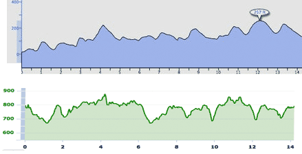
Today was a big day for me -- my last long midweek run before Big Sur. I did 14 miles, and the longest run on the midweek schedule between now and May 1 is a 10 miler next week that I'll probably trim down to 9. Since we're starting to get a sense of what the course will be like, I decided to run a fairly hilly route to see how the local terrain compares to Big Sur. Here's what I came up with:


The elevation profile on the bottom is the route I ran today. On top is Brian Rowlett's profile of a portion of the Big Sur course. I've normalized the vertical and horizontal scales on the two graphs, so a hill that's the same size on both graphs should be about the same size in real life. The fact that my course is a little more "jagged" than Brian's is probably due to differences in the smoothing algorithms our running software uses (or the fact that there are fewer trees in Big Sur)—my experience running here is not a bunch of tiny little hills, and from what I've read about Big Sur, there aren't hills like that there either.

But take a look at the larger hills and what you'll find is that they're actually pretty similar. I count about six major hills on my route and five on the Big Sur route. I think the hills on my local route are a bit bigger than the hills in Big Sur, though, and this is reflected in our overall GPS figures. My GPS recorded a cumulative elevation gain of 990 feet over 14.2 miles, while Brian recorded 1,203 vertical feet in 24.2 miles. That works out to about 700 vertical feet over 14.2 miles of Brian's route, compared to 990 for my route. It's looking like my route today was just a bit hillier than the Big Sur course.

I took it easy today, running this route at roughly a 9-minute pace. Could I run a course like that at an 8-minute pace, adding an extra 12 miles? Assuming the weather cooperates and I'm healthy, after a nice taper and four days of carbo-loading, I think it just might be possible.

Details of today's workout are below:

Wednesday, April 6, 2011

Some thoughts about the revised Big Sur course

A few weeks ago, a landslide took out a portion of Highway 1 along the Big Sur Marathon route:


The news from the marathon organizers is that the road will not be repaired in time for the race on May 1, so they will have to revise the route. The traditional route for the course runs from Big Sur to Carmel, California, a point-to-point course along Highway 1:


The landslide occurred between Hurricane Point and Bixby Bridge, two of the most dramatic spots along the run. Hurricane Point is the top of an epic 2-mile, 500-vertical-foot climb, and Bixby Bridge is a huge, high bridge that affords fantastic views of the ocean and coastline.

Since the route has been cut almost perfectly in two, the new course will be an out-and-back, from Carmel south to a point-to-be-determined. Despite the fact that Bixby is almost an exact halfway point, the course won't be going that far. Instead, it will turn around at some point before that, and add an extra 1.6 mile loop into Point Lobos State Park near the start/finish. By all accounts this should be a spectacular addition to the course.

So how will this revised course affect the race? Fortunately, local runner Brian Rowlett has provided a partial answer, which he kindly posted to the Big Sur Marathon facebook page. Check this out:


The elevation profile on the bottom shows the original course, as he ran it last year. On top is an out-and-back he ran last Sunday to Mile 14 on the original course, between Palo Colorado Canyon and Bixby Bridge. He didn't run the loop into Point Lobos, but otherwise it gives a good sense of the terrain runners will be likely to encounter when they run the race. His GPS gives a 1,751-foot elevation gain for the original course, compared to a 1,201-foot gain for the revised course (he thinks the Point Lobos spur will be "very slightly down then back up"). So the new course won't be quite as challenging. Indeed, if his GPS tracks elevation in a similar fashion to my own, it shouldn't be much hillier than the Thunder Road half marathon, which I recorded as a 551-foot cumulative gain (which would be 1,102 for a full).

It's nice that the course is easier, but I'm actually quite disappointed that the race won't be as much of a challenge. That's what I signed up for, not a prettified version of Thunder Road. From what I've read, the new course is quite spectacular, and the Point Lobos loop should be a dramatic addition. But still...

That said, I now need to start thinking about strategy for the new course. Aside from the fact that there are fewer hills, a couple of things stand out for me. First, instead of a downhill start, the beginning of the race is now predominantly uphill. Yes, it's rolling hills, but the downs are going to add up to less than the ups are -- the highest point on the course will be the halfway point. Second, there's no big, dramatic climb. The biggest hill looks to be around Mile 4 (and repeated around Mile 20), and it's only 100 or so vertical feet. So while on the original course there was a temptation to bank some time in the first 5 miles, on this course, there should not be. If you get through Mile 4 at a slightly slower pace than your target pace, you're probably running the course perfectly. 

In my case, I'd be happy to run Miles 1-4 at an 8:10 pace. If everything goes according to plan, I should be able to gradually pick up the pace over the remainder of the race and complete the marathon at an average 8:00 pace. I'd much rather start a little slow than start too fast and hit the wall at Mile 20.

Details of today's run are below.

Tuesday, April 5, 2011

Weather or not

Looking at the weather report last night, I was torn. There were thunderstorms forecast all night long, but they were slated to end around 6:00. But when exactly? Our regular Tuesday DART run is scheduled for 6 a.m. If the storms ended at 5:45, then a run should be no problem, but if the stormy weather continued until 6:45, it could be dangerous. I decided to set my alarm for 5:30 and reassess.

When I awoke, I couldn't hear any rain on the roof. I checked the weather again and it looked like we were in a lull, with only "showers" and no lightning in the forecast. I put on a pair of shorts and a compression shirt and headed downstairs, checking Facebook as I put my shoes on. No one had posted a definite "I won't be there" but since it had been thundering all night, I wouldn't be surprised if no one showed up. Chad, the most reliable Tuesday companion, had just run a hundred miler this weekend and would only be showing up for coffee afterwards, if at all.

I drove into town, noting that there were small downed branches everywhere. I waited until 6:02 to confirm that no one would be showing up. Then I decided to head out at a fairly quick pace. There was no rain, it was quite warm, but also windy. The first mile was downhill into a strong headwind: 7:40. Mile 2 was surrounded by trees on the uphill segment, and again featured a downhill-into-the-wind section: 7:32. Mile 3 is usually the fastest on the DART loop. There was a little wind here, but not enough to really slow me down: 7:13. Mile 4 was annoying. My shoe came untied twice. Once again, however, only the downhill section was into the wind. As I started the long, nearly constant uphill segment that went from Mile 3.5 to 5.5, I had a nice crosswind to keep me cool in the 60-degree weather; my split was 7:31.

Mile 5 is always the mile that determines how the DART loop will go; it's nearly all uphill. I used to strive for an 8-minute pace on this mile, but as I've gotten faster, I try to push the time on this mile closer to 7:45 or 7:40. Today I completed it in 7:42. Mile 6 starts out uphill, then heads down and back into town. At this point the rain started coming down hard. After about 30 seconds of rain my glasses were useless and I took them off. This made it harder to see the branches that were littering the sidewalk -- and the runners and walkers headed my direction. I kept pushing as hard as I could, avoiding several branches and people at the last second. Mile 6's pace: 7:40 -- a little slower than I would have run it under normal conditions. Finally I cruised back into town for a 7:28 pace for the final 0.36 miles. That was a 47:55 loop, a 7:32 pace; my second-fastest ever. Not bad given the weather!

Since I had pushed pretty hard on the run I decided to do a bit of a cooldown, about another mile at a 9:30 pace. Then I got back to the car and changed into a new shirt before heading over to Summit for coffee.

Details of today's run are below:

Sunday, April 3, 2011

The last 20 miler

The Big Sur Marathon is just four weeks away. That means soon I'll begin my taper, gradually decreasing the total number of miles run and the length of my longest run. But there was no rest this week—I was determined to keep my mileage up this week after two relatively easy weeks. So today I needed to do a 20-miler.

My original plan had been to run last week's long run like a marathon preview, running 18 miles with the last 14 at race pace. But the lure of participating in the National Half Marathon was too strong, so that plan was scrapped. This week was planned as just a regular 20 miler, but I had half a mind to run the last part faster—maybe not quite at race pace, but not at 9-minute pace either.

I had set my alarm for 5:30 so I could get in 6 miles before meeting up with the group, who were interested in 13 miles at the most. As it happened, I woke up at 5:20, and I took that as a sign I should try to get 7 miles in so that I didn't have to make up any miles after the group was finished. By 5:50, I was ready to go in front of the CVS where the DART group normally meets up. I started off with a four-mile DART loop at an easy 9-minute pace. It was dark, but the birds were already up, so I did have a little "company" along my run. I returned to the car, ate some GU and drank some water, then headed out again. I decided on an out-and-back to the college trails, so I could turn around whenever I needed to in order to meet up with the group at 7. Again, I took these miles at an easy 9-minute pace, knowing the group would be running faster.

I arrived at the CVS at 6:58 and met up with Todd, Matt, Tim, Terry, Jeremy, Mark, and Gabrielle. Todd is doing a marathon next week, so he only wanted to do 7, as did Jeremy and Gabrielle. That left me, Matt, Tim, Terry, and Mark planning on 13. Mark ended up having to turn back after only a mile or so due to a sore hamstring. Tim, Matt, Todd, Jeremy, and I cranked out three and a half sub-8-minute miles before I decided I should probably slow down a bit. At Mile 11 I stopped for a gel and waited for Terry to catch up. We stayed together for the next three or four miles, running 8:20-ish miles. As Terry started to fade a bit, I took off and did Mile 16 in 8:15.

I knew the last four miles on Grey Road would be very hilly (they are part of my "hill route), but I wanted to try to pick up the pace. Unfortunately my legs didn't cooperate. My splits were 8:32, 8:27, 8:35, 8:27. Not bad for miles that included 267 feet of climbing, but not quite what I hoped for. Still, if you compare my splits to some earlier runs at this distance, I didn't do bad, especially when you consider the hilly finish:


My finish wasn't quite as fast as February 20, but today I was running a very hilly route at the end, while on the 27th I was doing the relatively easy DART 4-mile route (that said, we did a pretty hilly run that day!).

Overall I averaged 8:32 per mile, and 8:19 on miles 8-20. This compares pretty well to the 8:32 average on February 20 and 8:58 on February 13.

Week in review:

7 runs
69.33 miles -- my most ever
Elevation gain: 3,019 feet -- a lot!
Average elevation gain: 503 feet, not counting yesterday when I didn't have my Garmin on

Details of today's run are below.

Saturday, April 2, 2011

Volunteering is hard work!

Today I had my first-ever race volunteer gig as run spotter for the Pawz Too Run 5K in Davidson. I figured it wouldn't be too tough a job since I live just 1.3 miles from the starting line. The race started at 8:00 a.m., and volunteers were expected to show up at 7:15. This was just enough time for the race director to explain the route and send us off to our stations. I would be handling the turnaround on Pine Road -- this was a pretty important spot, because if runners missed the turnaround, they could continue on for miles in the wrong direction.

I had run in from home, so I was wearing light running gear and was a bit worried about being cold, so at 7:30, when I was headed toward my station, I decided to grab a cup of coffee at Summit. Here's the race route:


As you can see, I was stationed about 1.7 miles from the start. I had to carry my coffee, a big "5K turnaround" sign, and a map of the course. As I strolled down South Street at 7:40, I realized that I probably wouldn't reach my station in time just by walking: If the frontrunners were running a sub-6-minute pace, they'd arrive at the turnaround around 8:10. Walking 3 miles per hour, I'd arrive at about 8:15! I needed to run. When I started to run, my coffee sloshed all over the place, so I had to stop every 50 meters or so to try to drink it down. On top of that, I was wearing an old (pre-30-pound-weight-loss) pair of sweats and they were starting to fall down -- and I didn't have a free hand to pull them up.

When I reached the 1-mile marker, I decided to ditch the coffee and run up Avinger carrying just the sign. I arrived at Pine road about 7:55 -- the race should be starting in just a few minutes. I told the spotters there what to expect, then turned down Pine and started to look for the turnaround. The race director had told me that it was marked in the road with "faint" spray paint, but also gave me a slip of paper on which he had scrawled the address of the house next to the turnaround. Did I still have the slip of paper? What was that address? I think it was 610 Pine Road. I passed what looked like a turnaround spot at around 430. Could that be it? I kept running down Pine. The street petered out before the address numbers reached 600, and I didn't see any markers. Maybe that earlier marker was the real spot...

I sprinted back up the road before realizing that I should probably check my pockets for that slip of paper. As I arrived back at the first turnaround, around 8:03, I finally found the address -- it was 560, not 610! I ran back down the road and finally found the very faintly painted turnaround marker in the street at about 8:08 a.m. Then I hiked my pants up, turned around and started looking for runners. Fortunately, no one had reached Pine Road yet.

At about 8:15, I began to worry. Shouldn't the leaders be here by now? Since the turnaround was before the 2-mile marker, that would be worse than a 7:30 pace. Surely someone would be faster than that. Had one of the spotters pointed the runners the wrong way? Of course, it was always possible that the race had started late. After a couple more tense moments, I finally saw the first runner charging towards me down Pine Road.

Now, for the next awkward moment: There was no physical turnaround marker. Most races I've been in use cones or some other physical marker to mark the course. This race had none, other than the mile markers. I decided that I'd have to serve as the turnaround marker. I yelled to the runner, who I now recognized as Bobby Aswell, a DARTer who I've interacted with on Facebook but never met in person, telling him to run around me and head back into town. He seemed a little confused but figured it out fairly quickly.

Next came Todd Hartung, another DARTer and a good friend of mine who'll be running with me in Big Sur. He was looking strong for second place (he did finish in second, with a 19:30 PR). Eventually I saw several more DARTers and others I recognized, including Mark Ippolito, who had just edged me out in the UNCC Homecoming 5K. Then, after the main pack of runners passed, I started to wonder how long I'd need to stay. Perhaps some walkers would be straggling in. Sure enough, I saw two groups of walkers make their way down Pine Road. Finally, about 35 minutes after the start, I was convinced that the last runner had passed. She had a determined, slow, steady jog, but this was clearly a difficult run for her. As she made her way back up Pine Road and the finish, I saw DARTer Tim Gruber and his Cannon School cross-country teammate Stephanie Schauder coming down the road on their cool down run. They turned around when they met up with this final runner, and accompanied her back into town, chatting with her and offering words of encouragement.

I decided to jog along the course back into town to see who had won. A glance at the leaderboard confirmed that Bobby had won and Todd was second. I ran into Bobby and decided to introduce myself. Then I found Todd and congratulated him on his PR. Finally I jogged back home. Overall I ran about 6 miles in the course of not running this race. I even got some speed work in! Unfortunately, I didn't carry my Garmin along, so there's no record of my mad dash as I searched for the turnaround marker.

Friday, April 1, 2011

Good and hilly

I've noticed that whenever I do speed work, it seems to really wreak havoc on my legs, especially around my hips. I'm pretty sure this is related to the IT band issue I've been dealing with for some time now: The added stress of the fast runs aggravates the injury.

So this week, I've cut out all my speed work. On Tuesday I was supposed to run 5X600 intervals; I did a tempo run instead. Yesterday and today I was supposed to do easy 5 and 8 milers, ending with 100-meter strides, and I didn't do that either. But I didn't want to completely wimp out, so today I challenged myself to run my hilly route at a relatively fast pace: sub-8-minute miles. It's a 9-mile route, with little respite from hills throughout, a cumulative total of nearly 700 vertical feet. Here's the elevation profile:


I also decided to try a new bit of equipment, some KT tape. I didn't do as thorough a job as in this video, though:


I just used a half-piece of tape on each hip. I do think it might have actually helped a little bit.

I wanted to give myself a bit of a chance to warm up before I went all-out, so I ran Mile 1 in 8:52. I gradually built up speed so I'd hit the start of Mile 2 at an 8-minute pace (7:59 as it turned out). Mile 3 was where the big hills started. In fact, this mile was a solid 162-foot climb: 7:57 (!). Then I headed downhill, trying to build up even more speed, 7:36. This course is like a lollipop, but I go around the top twice, so Mile 5 was once again a solid uphill, a 135-foot climb that I finished in 8:14. I was tiring, so I didn't hit the downslope of Mile 6 quite as fast: 7:50. Finally, Mile 7 completed the second loop of the lollipop and headed back towards home: 108 feet up, 92 feet down, 8:07.

I think I'm most proud today of my performance on Mile 8, which includes the notorious Grey Road climb back into Davidson. This is a hill that starts out fairly steep, but then just keeps on going at a reduced pitch before finally cresting after a hundred foot climb in a little over a half a mile. I finished the mile in 7:59. Mile 9 was no slouch either, starting off downhill but ending in an 82-foot climb that feels bigger: 7:46.

My overall pace for the run was 8:03, but that includes the warmup mile. Remove that, and I averaged 7:57. I decided to cool down for a half-mile or so and then headed home. Not bad for a Friday morning!

Details of the run are below: